Viet Nam was a country of extremes. The weather was no exception. During their dry season it was blistering hot -- the daytime temperatures
were often 100+ degrees. During the rainy season -- the monsoons -- the temperature dropped into the seventies as thick clouds blanketed
the sky. You felt as if you would sweat to death and then, strangely, during the monsoons... you thought you might freeze to death. During
the monsoons everything was wet! Our underground sleeping quarters often had three or four inches of water in them. You frequently
had to battle five- to six-inch long bright orange centipedes to get to your cot.
In I Corp (the northern part of South Viet Nam) the lush river plains were bounded by what appeared to be steep-sided mountains...
some rising to 5000 feet or more above sea level. However, much of I Corp could be better described by saying that it consisted of
a high plateau punctuated by deep river beds. The mountains rose out of the high plateau. Looking at the steep sides from the river beds,
it was easy to think that you were looking at the mountains themselves. In fact, you were just looking at the sides of the plateau as it
dropped to meet the river bed. This is why this area was referred to as "the central highlands" of Viet Nam. Indeed, several
of the maps list this area as 'the Annam Highlands'.
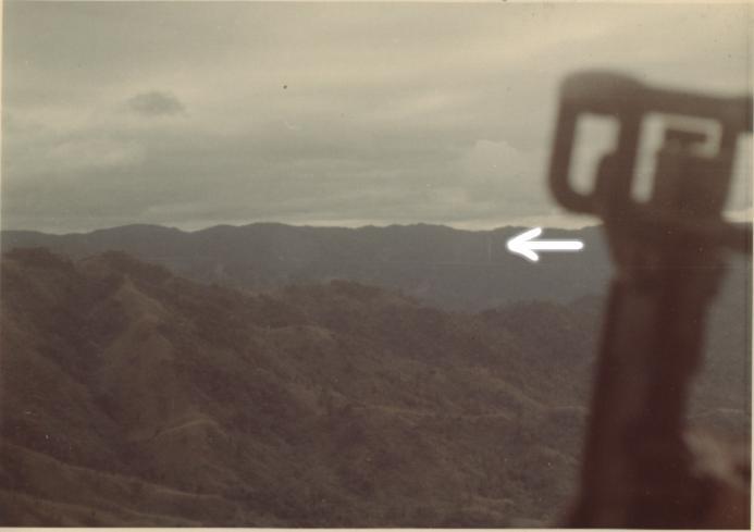
Terrain around Gia Vuc (A-103)...
This picture illustrates the mountainous terrain around the Special Forces camp at Gia Vuc. I used to say that Vietnam had two types of
terrain: flat and vertical. The abrupt changes in elevation created many cliffs and waterfalls. The white arrow points to a waterfall that was
visible kilometers away.
Young and fearless
Since the only means to reach SF camps was by air, most A-team members had many rides on heliocopters.On many occassions we would sit on the floor in the open door of the chopper with our feet propped on the chopper's skids -- no seat belts or anything. Flying along the coast at one or two hundred feet above the surfgave us a great view to see the sharks cruising the area just beyond the surf. We would use the sharks for M-16 target practice as we flew overhead. It was great fun. Would I ride, unrestrained, in the open door of a chopper now? No way!!
Terrain around Thuong Duc (A-109)...
Perhaps a better example of the 'high plateau' topology would be the picture showing the area around Thuong Duc, RVN. Special Forces A-109
was another 'typical' SF camp -- accessible only by air. Team members got used to riding in the Hueys. The open chopper doors often provided
an excellent opportunity to get pictures, such as the one below
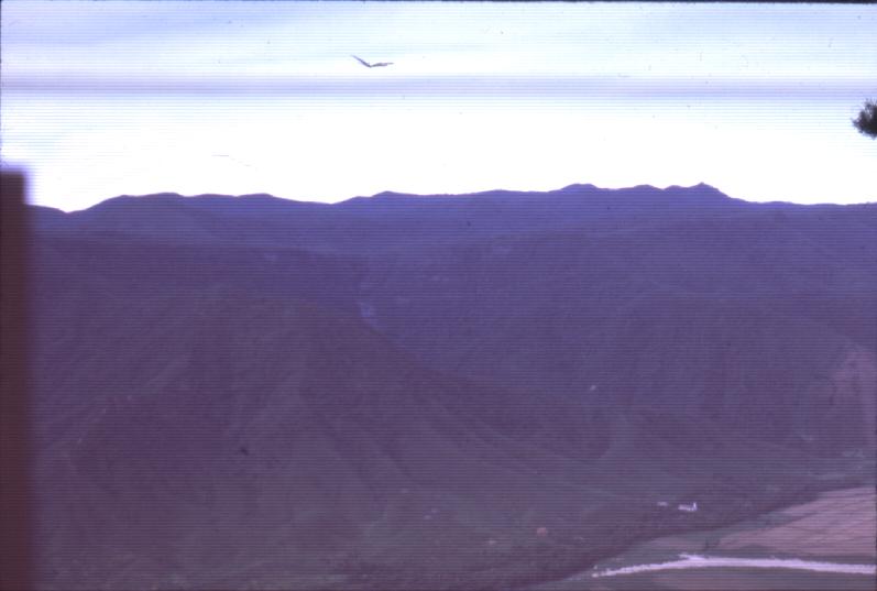
This picture was taken enroute to Thuong Duc and very near the camp. Note the pronounced plateau with the low river valley. The river can
be seen snaking its way to the South China Sea at the bottom-right corner. Sharply defined ridges or 'fingers' provide the transition
between the plateau and the river plains. Also note that the actual mountains rise out of the high plateau! The A-109 portion of the web
site has some excellent photos illustrating the severity of the terrain in and around Thuong Duc.
This picture provides bird's-eye view (pun intended) of the high plateau. The Thuong Duc A-109 Special Forces camp is to the right of the picture -- just out
of the camera's view. Note: Util I was preparing this slide for the web site, I never noticed the bird (?) in the picture.
The church
The white church, near the bottom-right corner of the photo, was approximately two kilometers from the camp. Since this distance was just about the same as the maximum effective range of our fifty caliber machine gun, the church was often used as the target for our fifty caliber gun tests.
The bare hillside
If you look closely, you will notice that the hillside (center, right-hand edge of picture) is brown when the remainder of the terrain is green. The Vietnamese would intentionally set the foliage on fire... in a sense, start a 'forest fire'. Because it was so wet in Viet Nam, there was little fear that the fire would burn wildly out of control. Eventually, this fire would die out. The Vietnamese would then cross the river and collect the charred wood. They set the fire to produce charcoal for their homes!
Steep terrain
I have pointed out the ruggedness of the terrain several times throughout this web site. This picture, perhaps better than any other, illustrates the severity of the elevation changes. When you couple the rapid changes in height with the dense vegetation and constantly wet conditions, you end up with terrain that is extremely -- almost impossibly -- difficult to traverse. There were times when it took our patrol eight (8) hours to go 400 to 1000 meters through the jungle.